


genicourt

jcb48
User
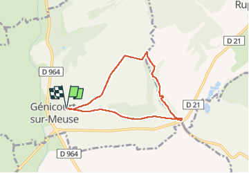

Length
6 km

Max alt
320 m

Uphill gradient
117 m
Km-Effort
7.6 km

Min alt
226 m

Downhill gradient
115 m
Boucle
Yes
Creation date :
2024-08-08 08:20:30.264
Updated on :
2024-08-08 10:44:49.022
2h24
Difficulty : Medium

FREE GPS app for hiking
 SityTrail
IGN / Geographical institutes
SityTrail Plus
The world is yours!
About
Trail Walking of 6 km to be discovered at Grand Est, Meuse, Génicourt-sur-Meuse. This trail is proposed by jcb48.
Description
marche
Positioning
Country:
France
Region :
Grand Est
Department/Province :
Meuse
Municipality :
Génicourt-sur-Meuse
Location:
Unknown
Start:(Dec)
Start:(UTM)
678276 ; 5434329 (31U) N.
Comments