


zap août 2024 villey

ISAGIL
User
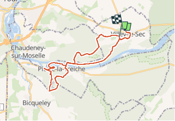

Length
16.2 km

Max alt
329 m

Uphill gradient
268 m
Km-Effort
19.8 km

Min alt
205 m

Downhill gradient
286 m
Boucle
No
Creation date :
2024-08-10 07:35:12.024
Updated on :
2024-08-10 12:44:59.326
4h16
Difficulty : Very difficult

FREE GPS app for hiking
 SityTrail
IGN / Geographical institutes
SityTrail Plus
The world is yours!
About
Trail Walking of 16.2 km to be discovered at Grand Est, Meurthe-et-Moselle, Villey-le-Sec. This trail is proposed by ISAGIL.
Positioning
Country:
France
Region :
Grand Est
Department/Province :
Meurthe-et-Moselle
Municipality :
Villey-le-Sec
Location:
Unknown
Start:(Dec)
Start:(UTM)
718794 ; 5393706 (31U) N.
Comments