


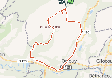
Orrouy_Les ruines gallo-romaines de Champlieu_8,3km

Pousscailleux
User

Length
8.3 km

Max alt
141 m

Uphill gradient
129 m
Km-Effort
10 km

Min alt
50 m

Downhill gradient
129 m
Boucle
Yes
Creation date :
2015-05-02 00:00:00.0
Updated on :
2015-05-02 00:00:00.0
2h12
Difficulty : Easy

FREE GPS app for hiking
 SityTrail
IGN / Geographical institutes
SityTrail Plus
The world is yours!
About
Trail Walking of 8.3 km to be discovered at Hauts-de-France, Oise, Orrouy. This trail is proposed by Pousscailleux.
Description
Départ du parking près du monument commémoratif du Camp des Chars d'Assaut de 1916-1918.
Coordonnées : N49°18'39.38"/E002°51'24.62"


Positioning
Country:
France
Region :
Hauts-de-France
Department/Province :
Oise
Municipality :
Orrouy
Location:
Unknown
Start:(Dec)
Start:(UTM)
489599 ; 5462039 (31U) N.
Comments