


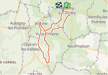
La Boufleyye

mjh
User

Length
14.3 km

Max alt
308 m

Uphill gradient
376 m
Km-Effort
19.3 km

Min alt
175 m

Downhill gradient
378 m
Boucle
Yes
Creation date :
2024-08-11 08:41:03.805
Updated on :
2024-08-11 13:32:50.342
3h57
Difficulty : Difficult

FREE GPS app for hiking
 SityTrail
IGN / Geographical institutes
SityTrail Plus
The world is yours!
About
Trail Walking of 14.3 km to be discovered at Grand Est, Ardennes, Rouvroy-sur-Audry. This trail is proposed by mjh.
Photos


Positioning
Country:
France
Region :
Grand Est
Department/Province :
Ardennes
Municipality :
Rouvroy-sur-Audry
Location:
Unknown
Start:(Dec)
Start:(UTM)
607258 ; 5515995 (31U) N.
Comments