


11/08/24 - Soultzeren

delm
User
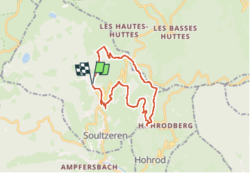

Length
13.5 km

Max alt
952 m

Uphill gradient
495 m
Km-Effort
20 km

Min alt
597 m

Downhill gradient
501 m
Boucle
Yes
Creation date :
2024-08-11 09:28:18.0
Updated on :
2024-08-11 15:20:46.202

FREE GPS app for hiking
 SityTrail
IGN / Geographical institutes
SityTrail Plus
The world is yours!
About
Trail of 13.5 km to be discovered at Grand Est, Haut-Rhin, Soultzeren. This trail is proposed by delm.
Description
Très belle randonnée
Positioning
Country:
France
Region :
Grand Est
Department/Province :
Haut-Rhin
Municipality :
Soultzeren
Location:
Unknown
Start:(Dec)
Start:(UTM)
358260 ; 5326920 (32U) N.
Comments