


déco parapente Targasonne

whisper73
User
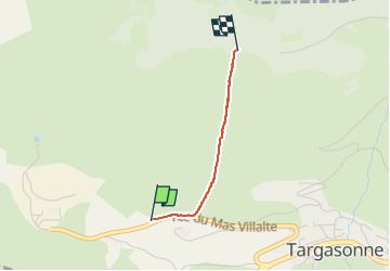

Length
1.5 km

Max alt
2064 m

Uphill gradient
416 m
Km-Effort
5.7 km

Min alt
1641 m

Downhill gradient
6 m
Boucle
No
Creation date :
2024-08-12 05:24:15.911
Updated on :
2024-08-12 06:18:41.635
53m
Difficulty : Difficult
15m
Difficulty : Easy

FREE GPS app for hiking
 SityTrail
IGN / Geographical institutes
SityTrail Plus
The world is yours!
About
Trail Walking of 1.5 km to be discovered at Occitania, Pyrénées-Orientales, Targassonne. This trail is proposed by whisper73.
Positioning
Country:
France
Region :
Occitania
Department/Province :
Pyrénées-Orientales
Municipality :
Targassonne
Location:
Unknown
Start:(Dec)
Start:(UTM)
416370 ; 4705846 (31T) N.
Comments