


2024-08-12_13h26m56_t299370154_ts2024_2

Marc-Hubert
User
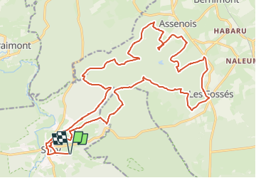

Length
27 km

Max alt
471 m

Uphill gradient
537 m
Km-Effort
34 km

Min alt
337 m

Downhill gradient
535 m
Boucle
Yes
Creation date :
2024-08-12 11:26:56.776
Updated on :
2024-08-12 11:26:58.514

FREE GPS app for hiking
 SityTrail
IGN / Geographical institutes
SityTrail Plus
The world is yours!
About
Trail of 27 km to be discovered at Wallonia, Luxembourg, Chiny. This trail is proposed by Marc-Hubert.
Positioning
Country:
Belgium
Region :
Wallonia
Department/Province :
Luxembourg
Municipality :
Chiny
Location:
Unknown
Start:(Dec)
Start:(UTM)
673611 ; 5514988 (31U) N.
Comments