


240812 - Tignes - Palafour-Chardonnet

randodan
User
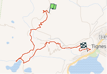

Length
5.1 km

Max alt
2552 m

Uphill gradient
26 m
Km-Effort
6.9 km

Min alt
2103 m

Downhill gradient
462 m
Boucle
No
Creation date :
2024-08-12 08:11:24.75
Updated on :
2024-08-12 12:45:20.026
4h33
Difficulty : Medium

FREE GPS app for hiking
 SityTrail
IGN / Geographical institutes
SityTrail Plus
The world is yours!
About
Trail Walking of 5.1 km to be discovered at Auvergne-Rhône-Alpes, Savoy, Tignes. This trail is proposed by randodan.
Positioning
Country:
France
Region :
Auvergne-Rhône-Alpes
Department/Province :
Savoy
Municipality :
Tignes
Location:
Unknown
Start:(Dec)
Start:(UTM)
335336 ; 5038040 (32T) N.
Comments