


Bioule

Glurps
User
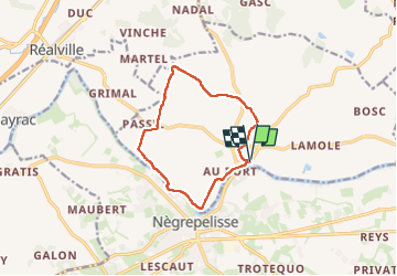

Length
10.9 km

Max alt
111 m

Uphill gradient
68 m
Km-Effort
11.8 km

Min alt
85 m

Downhill gradient
66 m
Boucle
Yes
Creation date :
2024-08-13 08:46:31.0
Updated on :
2024-08-13 11:33:03.125
2h45
Difficulty : Very easy

FREE GPS app for hiking
 SityTrail
IGN / Geographical institutes
SityTrail Plus
The world is yours!
About
Trail Walking of 10.9 km to be discovered at Occitania, Tarn-et-Garonne, Bioule. This trail is proposed by Glurps.
Positioning
Country:
France
Region :
Occitania
Department/Province :
Tarn-et-Garonne
Municipality :
Bioule
Location:
Unknown
Start:(Dec)
Start:(UTM)
383117 ; 4882903 (31T) N.
Comments