


Colombier Grignan taulignan 70km

thonyc
User GUIDE
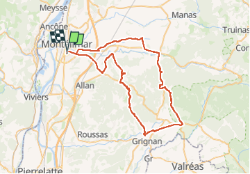

Length
70 km

Max alt
508 m

Uphill gradient
974 m
Km-Effort
83 km

Min alt
88 m

Downhill gradient
974 m
Boucle
No
Creation date :
2024-08-14 16:11:14.728
Updated on :
2024-08-14 16:14:24.424
5h02
Difficulty : Medium

FREE GPS app for hiking
 SityTrail
IGN / Geographical institutes
SityTrail Plus
The world is yours!
About
Trail Road bike of 70 km to be discovered at Auvergne-Rhône-Alpes, Drôme, Montélimar. This trail is proposed by thonyc.
Positioning
Country:
France
Region :
Auvergne-Rhône-Alpes
Department/Province :
Drôme
Municipality :
Montélimar
Location:
Unknown
Start:(Dec)
Start:(UTM)
639176 ; 4933818 (31T) N.
Comments