


SityTrail - 2023-10-05_09h12m35_venntrilogie-telecharger-fichier-gpx

guy284
User
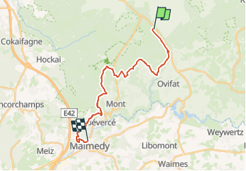

Length
19.8 km

Max alt
693 m

Uphill gradient
357 m
Km-Effort
26 km

Min alt
333 m

Downhill gradient
715 m
Boucle
No
Creation date :
2024-08-14 20:05:45.375
Updated on :
2024-08-15 06:17:01.781
5h50
Difficulty : Very difficult

FREE GPS app for hiking
 SityTrail
IGN / Geographical institutes
SityTrail Plus
The world is yours!
About
Trail Walking of 19.8 km to be discovered at Wallonia, Liège, Waimes. This trail is proposed by guy284.
Positioning
Country:
Belgium
Region :
Wallonia
Department/Province :
Liège
Municipality :
Waimes
Location:
Robertville
Start:(Dec)
Start:(UTM)
293857 ; 5598487 (32U) N.
Comments