


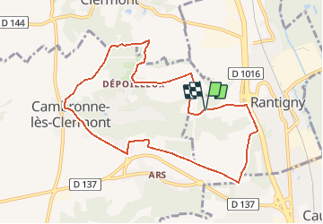
Rantigny_La croix de VauxTrace GPS simplifiée_9,0 km

Pousscailleux
User

Length
8.9 km

Max alt
127 m

Uphill gradient
126 m
Km-Effort
10.6 km

Min alt
50 m

Downhill gradient
128 m
Boucle
Yes
Creation date :
2015-05-03 00:00:00.0
Updated on :
2015-05-03 00:00:00.0
2h12
Difficulty : Easy

FREE GPS app for hiking
 SityTrail
IGN / Geographical institutes
SityTrail Plus
The world is yours!
About
Trail Walking of 8.9 km to be discovered at Hauts-de-France, Oise, Rantigny. This trail is proposed by Pousscailleux.
Description
Départ du parking du nouveau cimetière de Rantigny coordonnées GPS : N49°19'48.14"/E002°25'35.37"
Positioning
Country:
France
Region :
Hauts-de-France
Department/Province :
Oise
Municipality :
Rantigny
Location:
Unknown
Start:(Dec)
Start:(UTM)
458323 ; 5464301 (31U) N.
Comments