


St Heand Plaine du Forez par Balbigny

bena42
User
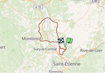

Length
115 km

Max alt
683 m

Uphill gradient
1099 m
Km-Effort
130 km

Min alt
316 m

Downhill gradient
1102 m
Boucle
Yes
Creation date :
2024-08-15 15:09:23.555
Updated on :
2024-11-01 17:53:47.437
7h51
Difficulty : Very difficult

FREE GPS app for hiking
 SityTrail
IGN / Geographical institutes
SityTrail Plus
The world is yours!
About
Trail Road bike of 115 km to be discovered at Auvergne-Rhône-Alpes, Loire, Saint-Héand. This trail is proposed by bena42.
Positioning
Country:
France
Region :
Auvergne-Rhône-Alpes
Department/Province :
Loire
Municipality :
Saint-Héand
Location:
Unknown
Start:(Dec)
Start:(UTM)
607234 ; 5045153 (31T) N.
Comments