


2024_trace_gpx_42km_belier_version_finale

gregou74
User

Length
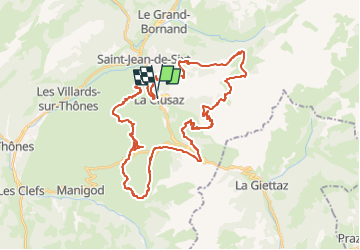
43 km

Max alt
1907 m

Uphill gradient
2149 m
Km-Effort
72 km

Min alt
1021 m

Downhill gradient
2152 m
Boucle
Yes
Creation date :
2024-08-16 10:46:56.0
Updated on :
2024-08-16 10:46:58.562

FREE GPS app for hiking
 SityTrail
IGN / Geographical institutes
SityTrail Plus
The world is yours!
About
Trail of 43 km to be discovered at Auvergne-Rhône-Alpes, Upper Savoy, La Clusaz. This trail is proposed by gregou74.
Positioning
Country:
France
Region :
Auvergne-Rhône-Alpes
Department/Province :
Upper Savoy
Municipality :
La Clusaz
Location:
Unknown
Start:(Dec)
Start:(UTM)
300091 ; 5086804 (32T) N.
Comments