


Chanterelle Adeps 2023

fra_depoorter
User
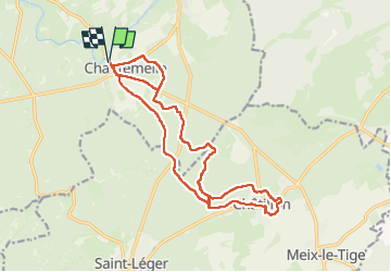

Length
18.7 km

Max alt
370 m

Uphill gradient
274 m
Km-Effort
22 km

Min alt
296 m

Downhill gradient
274 m
Boucle
Yes
Creation date :
2024-08-18 06:56:49.122
Updated on :
2024-08-18 11:12:41.105
4h14
Difficulty : Medium

FREE GPS app for hiking
 SityTrail
IGN / Geographical institutes
SityTrail Plus
The world is yours!
About
Trail Walking of 18.7 km to be discovered at Wallonia, Luxembourg, Étalle. This trail is proposed by fra_depoorter.
Positioning
Country:
Belgium
Region :
Wallonia
Department/Province :
Luxembourg
Municipality :
Étalle
Location:
Chantemelle
Start:(Dec)
Start:(UTM)
691254 ; 5503591 (31U) N.
Comments