


jasseron 1

ISAGIL
User
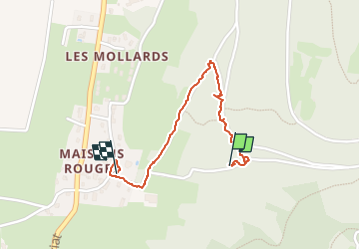

Length
1.4 km

Max alt
389 m

Uphill gradient
11 m
Km-Effort
1.7 km

Min alt
315 m

Downhill gradient
67 m
Boucle
No
Creation date :
2024-08-19 08:58:10.06
Updated on :
2024-08-19 09:45:21.769
46m
Difficulty : Easy

FREE GPS app for hiking
 SityTrail
IGN / Geographical institutes
SityTrail Plus
The world is yours!
About
Trail Walking of 1.4 km to be discovered at Auvergne-Rhône-Alpes, Ain, Jasseron. This trail is proposed by ISAGIL.
Description
marche
Positioning
Country:
France
Region :
Auvergne-Rhône-Alpes
Department/Province :
Ain
Municipality :
Jasseron
Location:
Unknown
Start:(Dec)
Start:(UTM)
679800 ; 5119113 (31T) N.
Comments