


Boucle Martel Gluges Martel

Nono55
User
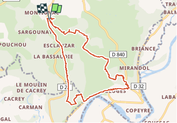

Length
11.5 km

Max alt
303 m

Uphill gradient
280 m
Km-Effort
15.3 km

Min alt
109 m

Downhill gradient
283 m
Boucle
Yes
Creation date :
2024-08-19 07:38:25.0
Updated on :
2024-08-19 18:56:46.842
2h11
Difficulty : Medium

FREE GPS app for hiking
 SityTrail
IGN / Geographical institutes
SityTrail Plus
The world is yours!
About
Trail Walking of 11.5 km to be discovered at Occitania, Lot, Martel. This trail is proposed by Nono55.
Description
Formidable balade sur le chemin botanique
Village de Gluges magnifique
Super points de vues
Positioning
Country:
France
Region :
Occitania
Department/Province :
Lot
Municipality :
Martel
Location:
Unknown
Start:(Dec)
Start:(UTM)
390009 ; 4975978 (31T) N.
Comments