


Le pas trop mal

Thibaut Esteban
User
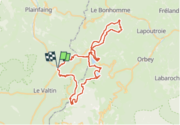

Length
39 km

Max alt
1300 m

Uphill gradient
1956 m
Km-Effort
65 km

Min alt
700 m

Downhill gradient
1956 m
Boucle
Yes
Creation date :
2024-08-20 11:14:43.217
Updated on :
2024-08-20 11:14:48.877
14h47
Difficulty : Very difficult

FREE GPS app for hiking
 SityTrail
IGN / Geographical institutes
SityTrail Plus
The world is yours!
About
Trail Walking of 39 km to be discovered at Grand Est, Vosges, Plainfaing. This trail is proposed by Thibaut Esteban.
Positioning
Country:
France
Region :
Grand Est
Department/Province :
Vosges
Municipality :
Plainfaing
Location:
Unknown
Start:(Dec)
Start:(UTM)
354293 ; 5331407 (32U) N.
Comments