


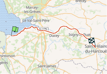
Mont St Michel - St Hilaire 42 km

jeanmarcMasson
User GUIDE

Length
37 km

Max alt
115 m

Uphill gradient
300 m
Km-Effort
41 km

Min alt
4 m

Downhill gradient
245 m
Boucle
No
Creation date :
2024-08-20 08:15:38.63
Updated on :
2024-08-20 13:28:08.976
3h35
Difficulty : Very difficult

FREE GPS app for hiking
 SityTrail
IGN / Geographical institutes
SityTrail Plus
The world is yours!
About
Trail Bicycle tourism of 37 km to be discovered at Normandy, Manche, Pontorson. This trail is proposed by jeanmarcMasson.
Positioning
Country:
France
Region :
Normandy
Department/Province :
Manche
Municipality :
Pontorson
Location:
Pontorson
Start:(Dec)
Start:(UTM)
611415 ; 5385862 (30U) N.
Comments