


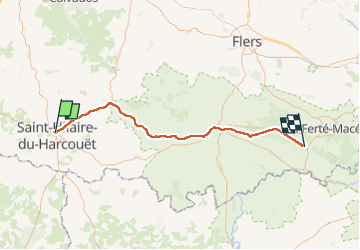
St Hilaire - Bagnole de l'orne 60 km

jeanmarcMasson
User GUIDE

Length
60 km

Max alt
274 m

Uphill gradient
646 m
Km-Effort
68 km

Min alt
62 m

Downhill gradient
518 m
Boucle
No
Creation date :
2024-08-21 07:07:48.551
Updated on :
2024-08-21 13:11:48.628
4h32
Difficulty : Very difficult

FREE GPS app for hiking
 SityTrail
IGN / Geographical institutes
SityTrail Plus
The world is yours!
About
Trail Bicycle tourism of 60 km to be discovered at Normandy, Manche, Saint-Hilaire-du-Harcouët. This trail is proposed by jeanmarcMasson.
Positioning
Country:
France
Region :
Normandy
Department/Province :
Manche
Municipality :
Saint-Hilaire-du-Harcouët
Location:
Saint-Hilaire-du-Harcouët
Start:(Dec)
Start:(UTM)
640303 ; 5382665 (30U) N.
Comments