


rando familiale après midi

okfred26
User
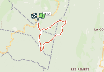

Length
5.5 km

Max alt
1446 m

Uphill gradient
183 m
Km-Effort
7.9 km

Min alt
1290 m

Downhill gradient
182 m
Boucle
Yes
Creation date :
2024-08-21 16:10:34.522
Updated on :
2024-08-21 16:09:52.798
1h47
Difficulty : Easy

FREE GPS app for hiking
 SityTrail
IGN / Geographical institutes
SityTrail Plus
The world is yours!
About
Trail Walking of 5.5 km to be discovered at Auvergne-Rhône-Alpes, Isère, Malleval-en-Vercors. This trail is proposed by okfred26.
Positioning
Country:
France
Region :
Auvergne-Rhône-Alpes
Department/Province :
Isère
Municipality :
Malleval-en-Vercors
Location:
Unknown
Start:(Dec)
Start:(UTM)
691465 ; 5000320 (31T) N.
Comments