


2024-08-22_15h42m32_Lac des sapins à cublize

Jean-Marc C
User
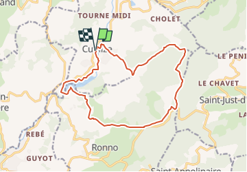

Length
16.4 km

Max alt
836 m

Uphill gradient
523 m
Km-Effort
23 km

Min alt
435 m

Downhill gradient
525 m
Boucle
Yes
Creation date :
2024-08-22 13:42:33.11
Updated on :
2024-08-22 14:56:34.182
5h18
Difficulty : Medium

FREE GPS app for hiking
 SityTrail
IGN / Geographical institutes
SityTrail Plus
The world is yours!
About
Trail On foot of 16.4 km to be discovered at Auvergne-Rhône-Alpes, Rhône, Cublize. This trail is proposed by Jean-Marc C.
Positioning
Country:
France
Region :
Auvergne-Rhône-Alpes
Department/Province :
Rhône
Municipality :
Cublize
Location:
Unknown
Start:(Dec)
Start:(UTM)
606688 ; 5097016 (31T) N.
Comments