


2024-08-23_15h41m18_De_Ruoms_a_Labeaume

raab
User
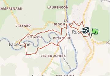

Length
10.3 km

Max alt
188 m

Uphill gradient
199 m
Km-Effort
13 km

Min alt
113 m

Downhill gradient
198 m
Boucle
Yes
Creation date :
2024-08-23 13:41:18.683
Updated on :
2024-08-23 13:51:22.223
2h57
Difficulty : Difficult

FREE GPS app for hiking
 SityTrail
IGN / Geographical institutes
SityTrail Plus
The world is yours!
About
Trail Walking of 10.3 km to be discovered at Auvergne-Rhône-Alpes, Ardèche, Ruoms. This trail is proposed by raab.
Positioning
Country:
France
Region :
Auvergne-Rhône-Alpes
Department/Province :
Ardèche
Municipality :
Ruoms
Location:
Unknown
Start:(Dec)
Start:(UTM)
607184 ; 4922856 (31T) N.
Comments