


2024-08-23_15h56m56_Ranc_de_l_Arche_en_boucle

raab
User
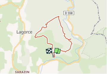

Length
6.9 km

Max alt
284 m

Uphill gradient
206 m
Km-Effort
9.6 km

Min alt
119 m

Downhill gradient
206 m
Boucle
Yes
Creation date :
2024-08-23 13:56:56.79
Updated on :
2024-08-23 13:57:26.383
2h11
Difficulty : Medium

FREE GPS app for hiking
 SityTrail
IGN / Geographical institutes
SityTrail Plus
The world is yours!
About
Trail Walking of 6.9 km to be discovered at Auvergne-Rhône-Alpes, Ardèche, Lagorce. This trail is proposed by raab.
Positioning
Country:
France
Region :
Auvergne-Rhône-Alpes
Department/Province :
Ardèche
Municipality :
Lagorce
Location:
Unknown
Start:(Dec)
Start:(UTM)
614139 ; 4921448 (31T) N.
Comments