Trail Walking Pujo-le-Plan - autour de Pujo le Plan - Photo

autour de Pujo le Plan

 papiou
papiou

User

© OpenStreetMap contributors
Length
Length
12.9 km
Max alt
Max alt
107 m
Uphill gradient
Uphill gradient
138 m
Km-Effort
Km-Effort  
14.7 km
Min alt
Min alt
67 m
Downhill gradient
Downhill gradient
139 m
Boucle
Boucle
Yes
Creation date :
2024-08-24 06:45:14.643
Updated on :
2024-08-24 11:48:49.661

(0 Reviews)

Walking
Walking
2h40
Difficulty : Medium

Scan this QR Code to open this trail in the SityTrail application

FREE GPS app for hiking

Logo SityTrail SityTrail

IGN / Geographical institutes

Download SityTrail from the App Store Download SityTrail from Google Play

Logo SityTrail SityTrail Plus

The world is yours!

Download SityTrail from the App Store Download SityTrail from Google Play Download SityTrail on Huawei AppGallery

About

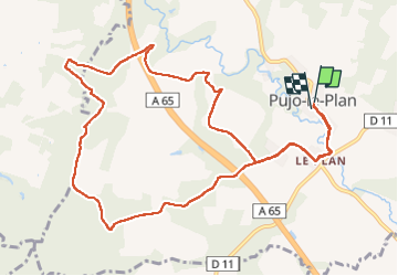
Trail Walking of 12.9 km to be discovered at New Aquitaine, Landes, Pujo-le-Plan. This trail is proposed by papiou.

Description

rdv mairie et dos à celle ci partir à gauche et suivre l'appli pour un circuit par route, près des champs et en forêt. Superbe circuit proposé par le Comité des fêtes de Pujo.
pour faire 10km, le départ peut se faire à l'église de Le Plan

Elevation profile

Positioning

Country:
France
Region :
New Aquitaine
Department/Province :
Landes
Municipality :
Pujo-le-Plan
Location:
Unknown
Start:(UTM)
714379 ; 4860027 (30T) N.


Close
My subscriptions