


Pennes le sec

m.rozeron
User
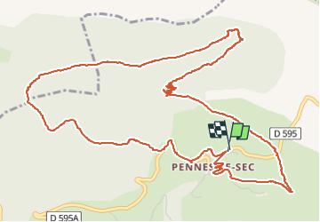

Length
7.9 km

Max alt
977 m

Uphill gradient
334 m
Km-Effort
12.3 km

Min alt
717 m

Downhill gradient
333 m
Boucle
Yes
Creation date :
2024-08-25 09:35:00.879
Updated on :
2024-08-25 12:32:14.037
2h08
Difficulty : Easy

FREE GPS app for hiking
 SityTrail
IGN / Geographical institutes
SityTrail Plus
The world is yours!
About
Trail Walking of 7.9 km to be discovered at Auvergne-Rhône-Alpes, Drôme, Pennes-le-Sec. This trail is proposed by m.rozeron.
Positioning
Country:
France
Region :
Auvergne-Rhône-Alpes
Department/Province :
Drôme
Municipality :
Pennes-le-Sec
Location:
Unknown
Start:(Dec)
Start:(UTM)
683870 ; 4945433 (31T) N.
Comments