


montmelas

Jean-Marc C
User

Length
9.6 km

Max alt
734 m

Uphill gradient
440 m
Km-Effort
15.5 km

Min alt
345 m

Downhill gradient
444 m
Boucle
Yes
Creation date :
2024-08-25 08:43:58.178
Updated on :
2024-08-25 14:21:33.101
5h36
Difficulty : Difficult

FREE GPS app for hiking
 SityTrail
IGN / Geographical institutes
SityTrail Plus
The world is yours!
About
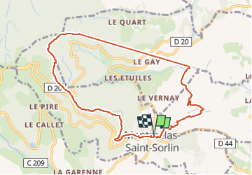
Trail Walking of 9.6 km to be discovered at Auvergne-Rhône-Alpes, Rhône, Montmelas-Saint-Sorlin. This trail is proposed by Jean-Marc C.
Photos


Positioning
Country:
France
Region :
Auvergne-Rhône-Alpes
Department/Province :
Rhône
Municipality :
Montmelas-Saint-Sorlin
Location:
Unknown
Start:(Dec)
Start:(UTM)
624672 ; 5096971 (31T) N.
Comments