


bossapas Meudon

c.chehere
User
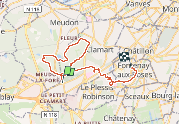

Length
15.8 km

Max alt
179 m

Uphill gradient
245 m
Km-Effort
19.2 km

Min alt
96 m

Downhill gradient
297 m
Boucle
No
Creation date :
2024-08-26 05:45:31.002
Updated on :
2024-08-26 12:50:25.831
4h24
Difficulty : Medium

FREE GPS app for hiking
 SityTrail
IGN / Geographical institutes
SityTrail Plus
The world is yours!
About
Trail Walking of 15.8 km to be discovered at Ile-de-France, Hauts-de-Seine, Clamart. This trail is proposed by c.chehere.
Photos


Positioning
Country:
France
Region :
Ile-de-France
Department/Province :
Hauts-de-Seine
Municipality :
Clamart
Location:
Unknown
Start:(Dec)
Start:(UTM)
443995 ; 5403889 (31U) N.
Comments