


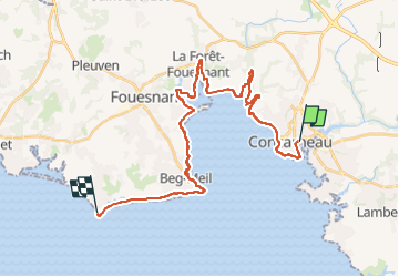
GR34-3 Concarneau Mousterlin 30km

thonyc
User GUIDE

Length
30 km

Max alt
25 m

Uphill gradient
241 m
Km-Effort
33 km

Min alt
0 m

Downhill gradient
245 m
Boucle
No
Creation date :
2024-08-27 11:57:27.98
Updated on :
2024-08-27 11:59:02.385
7h29
Difficulty : Medium

FREE GPS app for hiking
 SityTrail
IGN / Geographical institutes
SityTrail Plus
The world is yours!
About
Trail Walking of 30 km to be discovered at Brittany, Finistère, Concarneau. This trail is proposed by thonyc.
Positioning
Country:
France
Region :
Brittany
Department/Province :
Finistère
Municipality :
Concarneau
Location:
Unknown
Start:(Dec)
Start:(UTM)
431462 ; 5302927 (30T) N.
Comments