


Le rousset en vercors

raygautier
User
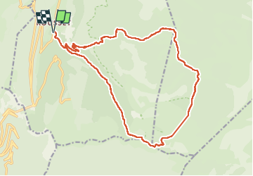

Length
21 km

Max alt
1724 m

Uphill gradient
832 m
Km-Effort
32 km

Min alt
956 m

Downhill gradient
831 m
Boucle
Yes
Creation date :
2024-08-29 06:08:05.0
Updated on :
2024-08-29 16:56:53.211
8h02
Difficulty : Very difficult

FREE GPS app for hiking
 SityTrail
IGN / Geographical institutes
SityTrail Plus
The world is yours!
About
Trail Walking of 21 km to be discovered at Auvergne-Rhône-Alpes, Drôme, Saint-Agnan-en-Vercors. This trail is proposed by raygautier.
Positioning
Country:
France
Region :
Auvergne-Rhône-Alpes
Department/Province :
Drôme
Municipality :
Saint-Agnan-en-Vercors
Location:
Unknown
Start:(Dec)
Start:(UTM)
690854 ; 4970849 (31T) N.
Comments