


les_cretes_de_frahan_poupehan_rochehaut-13775336

gdela
User
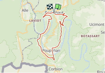

Length
14.5 km

Max alt
374 m

Uphill gradient
607 m
Km-Effort
23 km

Min alt
194 m

Downhill gradient
604 m
Boucle
Yes
Creation date :
2024-08-30 12:41:37.789
Updated on :
2024-08-30 12:45:36.263
5h08
Difficulty : Very difficult

FREE GPS app for hiking
 SityTrail
IGN / Geographical institutes
SityTrail Plus
The world is yours!
About
Trail Walking of 14.5 km to be discovered at Wallonia, Luxembourg, Bouillon. This trail is proposed by gdela.
Positioning
Country:
Belgium
Region :
Wallonia
Department/Province :
Luxembourg
Municipality :
Bouillon
Location:
Unknown
Start:(Dec)
Start:(UTM)
644318 ; 5522754 (31U) N.
Comments