les rochers des 4_fils_Aymon - 18609374

gdela
User
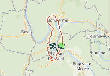

Length
12 km

Max alt
365 m

Uphill gradient
428 m
Km-Effort
17.8 km

Min alt
130 m

Downhill gradient
436 m
Boucle
Yes
Creation date :
2024-08-30 12:41:38.416
Updated on :
2024-08-30 12:44:38.851
4h02
Difficulty : Difficult

FREE GPS app for hiking
 SityTrail
IGN / Geographical institutes
SityTrail Plus
The world is yours!
About
Trail Walking of 12 km to be discovered at Grand Est, Ardennes, Bogny-sur-Meuse. This trail is proposed by gdela.
Positioning
Country:
France
Region :
Grand Est
Department/Province :
Ardennes
Municipality :
Bogny-sur-Meuse
Location:
Unknown
Start:(Dec)
Start:(UTM)
625022 ; 5524583 (31U) N.
Comments