


01/01/24 - Le DABO

delm
User
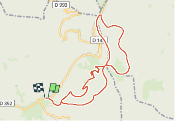

Length
10.3 km

Max alt
996 m

Uphill gradient
374 m
Km-Effort
15.3 km

Min alt
738 m

Downhill gradient
380 m
Boucle
Yes
Creation date :
2024-09-01 09:28:12.0
Updated on :
2024-10-16 15:37:58.085
3h29
Difficulty : Easy

FREE GPS app for hiking
 SityTrail
IGN / Geographical institutes
SityTrail Plus
The world is yours!
About
Trail On foot of 10.3 km to be discovered at Grand Est, Bas-Rhin, Grandfontaine. This trail is proposed by delm.
Positioning
Country:
France
Region :
Grand Est
Department/Province :
Bas-Rhin
Municipality :
Grandfontaine
Location:
Unknown
Start:(Dec)
Start:(UTM)
363334 ; 5374426 (32U) N.
Comments