


WANCHY-CAPVAL

juanluco76
User
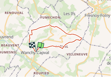

Length
11 km

Max alt
189 m

Uphill gradient
166 m
Km-Effort
13.3 km

Min alt
70 m

Downhill gradient
166 m
Boucle
Yes
Creation date :
2024-09-01 22:08:52.287
Updated on :
2024-09-01 22:10:03.28
3h00
Difficulty : Difficult

FREE GPS app for hiking
 SityTrail
IGN / Geographical institutes
SityTrail Plus
The world is yours!
About
Trail Walking of 11 km to be discovered at Normandy, Seine-Maritime, Wanchy-Capval. This trail is proposed by juanluco76.
Positioning
Country:
France
Region :
Normandy
Department/Province :
Seine-Maritime
Municipality :
Wanchy-Capval
Location:
Unknown
Start:(Dec)
Start:(UTM)
382013 ; 5524069 (31U) N.
Comments