


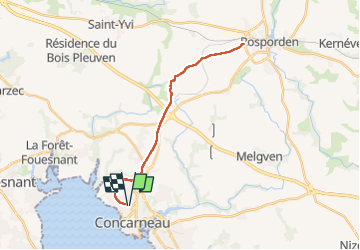
Concarneau-Rosporden voie verte

ollivier.albert
User

Length
25 km

Max alt
160 m

Uphill gradient
256 m
Km-Effort
29 km

Min alt
28 m

Downhill gradient
252 m
Boucle
Yes
Creation date :
2024-09-02 14:45:09.034
Updated on :
2024-09-02 17:32:51.754
1h38
Difficulty : Medium

FREE GPS app for hiking
 SityTrail
IGN / Geographical institutes
SityTrail Plus
The world is yours!
About
Trail Mountain bike of 25 km to be discovered at Brittany, Finistère, Concarneau. This trail is proposed by ollivier.albert.
Description
ancienne voie ferrée
Photos

Positioning
Country:
France
Region :
Brittany
Department/Province :
Finistère
Municipality :
Concarneau
Location:
Unknown
Start:(Dec)
Start:(UTM)
430863 ; 5303751 (30T) N.
Comments