


zap bouzey

ISAGIL
User
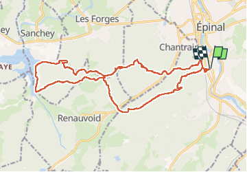

Length
22 km

Max alt
473 m

Uphill gradient
507 m
Km-Effort
29 km

Min alt
332 m

Downhill gradient
506 m
Boucle
Yes
Creation date :
2024-09-03 07:00:33.007
Updated on :
2024-09-03 14:07:51.795
6h12
Difficulty : Very difficult

FREE GPS app for hiking
 SityTrail
IGN / Geographical institutes
SityTrail Plus
The world is yours!
About
Trail Walking of 22 km to be discovered at Grand Est, Vosges, Épinal. This trail is proposed by ISAGIL.
Description
lac tourbiere
Positioning
Country:
France
Region :
Grand Est
Department/Province :
Vosges
Municipality :
Épinal
Location:
Unknown
Start:(Dec)
Start:(UTM)
310403 ; 5337316 (32U) N.
Comments