


Veselay

raygautier
User
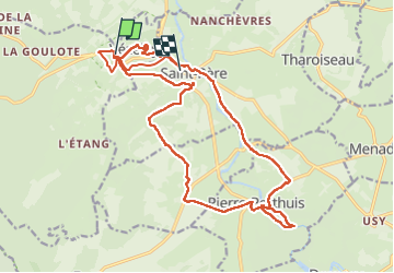

Length
23 km

Max alt
300 m

Uphill gradient
504 m
Km-Effort
30 km

Min alt
142 m

Downhill gradient
583 m
Boucle
No
Creation date :
2024-09-04 07:23:26.0
Updated on :
2024-09-04 14:03:29.53
6h39
Difficulty : Very difficult

FREE GPS app for hiking
 SityTrail
IGN / Geographical institutes
SityTrail Plus
The world is yours!
About
Trail Walking of 23 km to be discovered at Bourgogne-Franche-Comté, Yonne, Vézelay. This trail is proposed by raygautier.
Positioning
Country:
France
Region :
Bourgogne-Franche-Comté
Department/Province :
Yonne
Municipality :
Vézelay
Location:
Unknown
Start:(Dec)
Start:(UTM)
555810 ; 5257070 (31T) N.
Comments