


Concarneau pointe Mousterlin

thonyc
User GUIDE
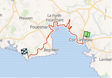

Length
25 km

Max alt
39 m

Uphill gradient
213 m
Km-Effort
28 km

Min alt
0 m

Downhill gradient
217 m
Boucle
No
Creation date :
2024-09-04 06:48:33.522
Updated on :
2024-09-04 16:30:36.393
9h06
Difficulty : Difficult

FREE GPS app for hiking
 SityTrail
IGN / Geographical institutes
SityTrail Plus
The world is yours!
About
Trail Walking of 25 km to be discovered at Brittany, Finistère, Concarneau. This trail is proposed by thonyc.
Positioning
Country:
France
Region :
Brittany
Department/Province :
Finistère
Municipality :
Concarneau
Location:
Unknown
Start:(Dec)
Start:(UTM)
431360 ; 5302588 (30T) N.
Comments