


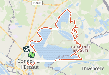
Boucle par la Grande Redoute

rigol05
User

Length
11.6 km

Max alt
66 m

Uphill gradient
130 m
Km-Effort
13.3 km

Min alt
12 m

Downhill gradient
134 m
Boucle
No
Creation date :
2024-09-05 08:50:24.197
Updated on :
2024-09-25 16:34:03.8
2h56
Difficulty : Medium

FREE GPS app for hiking
 SityTrail
IGN / Geographical institutes
SityTrail Plus
The world is yours!
About
Trail Walking of 11.6 km to be discovered at Hauts-de-France, Nord, Condé-sur-l'Escaut. This trail is proposed by rigol05.
Description
Rando du 04-09-2024
Itinéraire dans un ancien site minier, l'ascension du terrel permet de bénéficier d'un panorama à 360°
Photos


Positioning
Country:
France
Region :
Hauts-de-France
Department/Province :
Nord
Municipality :
Condé-sur-l'Escaut
Location:
Unknown
Start:(Dec)
Start:(UTM)
541988 ; 5588742 (31U) N.
Comments