


Modif Benodet Guivilec 22,5km

thonyc
User GUIDE
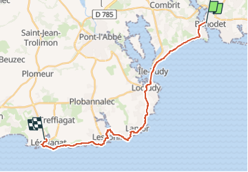

Length
23 km

Max alt
21 m

Uphill gradient
117 m
Km-Effort
24 km

Min alt
-1 m

Downhill gradient
117 m
Boucle
No
Creation date :
2024-09-05 06:57:25.196
Updated on :
2024-09-05 12:41:34.24
5h29
Difficulty : Medium

FREE GPS app for hiking
 SityTrail
IGN / Geographical institutes
SityTrail Plus
The world is yours!
About
Trail Walking of 23 km to be discovered at Brittany, Finistère, Bénodet. This trail is proposed by thonyc.
Positioning
Country:
France
Region :
Brittany
Department/Province :
Finistère
Municipality :
Bénodet
Location:
Unknown
Start:(Dec)
Start:(UTM)
416616 ; 5303044 (30T) N.
Comments