


Chassy

raygautier
User
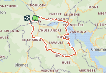

Length
16.6 km

Max alt
421 m

Uphill gradient
377 m
Km-Effort
22 km

Min alt
261 m

Downhill gradient
378 m
Boucle
Yes
Creation date :
2024-09-06 06:51:51.0
Updated on :
2024-09-06 12:53:53.246
6h01
Difficulty : Very difficult

FREE GPS app for hiking
 SityTrail
IGN / Geographical institutes
SityTrail Plus
The world is yours!
About
Trail Walking of 16.6 km to be discovered at Bourgogne-Franche-Comté, Nièvre, Montigny-en-Morvan. This trail is proposed by raygautier.
Positioning
Country:
France
Region :
Bourgogne-Franche-Comté
Department/Province :
Nièvre
Municipality :
Montigny-en-Morvan
Location:
Unknown
Start:(Dec)
Start:(UTM)
563020 ; 5223736 (31T) N.
Comments