


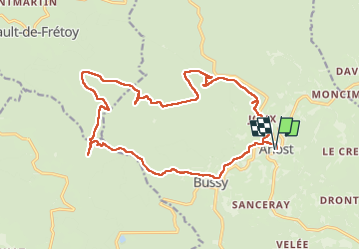
Boucle à ANOST

RC76
User

Length
20 km

Max alt
773 m

Uphill gradient
577 m
Km-Effort
28 km

Min alt
451 m

Downhill gradient
579 m
Boucle
Yes
Creation date :
2024-09-06 07:28:08.0
Updated on :
2024-11-20 13:41:04.243
4h58
Difficulty : Very difficult

FREE GPS app for hiking
 SityTrail
IGN / Geographical institutes
SityTrail Plus
The world is yours!
About
Trail Walking of 20 km to be discovered at Bourgogne-Franche-Comté, Saône-et-Loire, Anost. This trail is proposed by RC76.
Positioning
Country:
France
Region :
Bourgogne-Franche-Comté
Department/Province :
Saône-et-Loire
Municipality :
Anost
Location:
Unknown
Start:(Dec)
Start:(UTM)
583400 ; 5214348 (31T) N.
Comments