


Guilvinec Beuzec 23km

thonyc
User GUIDE
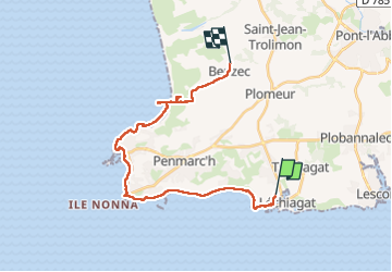

Length
23 km

Max alt
39 m

Uphill gradient
129 m
Km-Effort
25 km

Min alt
-1 m

Downhill gradient
103 m
Boucle
No
Creation date :
2024-09-07 07:02:17.602
Updated on :
2024-09-07 15:04:33.739
8h00
Difficulty : Medium

FREE GPS app for hiking
 SityTrail
IGN / Geographical institutes
SityTrail Plus
The world is yours!
About
Trail Walking of 23 km to be discovered at Brittany, Finistère, Guilvinec. This trail is proposed by thonyc.
Positioning
Country:
France
Region :
Brittany
Department/Province :
Finistère
Municipality :
Guilvinec
Location:
Unknown
Start:(Dec)
Start:(UTM)
404160 ; 5294699 (30T) N.
Comments