


Pierrefonds

tine60
User
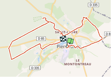

Length
11.7 km

Max alt
148 m

Uphill gradient
192 m
Km-Effort
14.2 km

Min alt
74 m

Downhill gradient
195 m
Boucle
Yes
Creation date :
2024-09-08 07:02:18.0
Updated on :
2024-09-08 10:12:27.799

FREE GPS app for hiking
 SityTrail
IGN / Geographical institutes
SityTrail Plus
The world is yours!
About
Trail of 11.7 km to be discovered at Hauts-de-France, Oise, Pierrefonds. This trail is proposed by tine60.
Positioning
Country:
France
Region :
Hauts-de-France
Department/Province :
Oise
Municipality :
Pierrefonds
Location:
Unknown
Start:(Dec)
Start:(UTM)
498318 ; 5466021 (31U) N.
Comments