


BRAMETOT

juanluco76
User
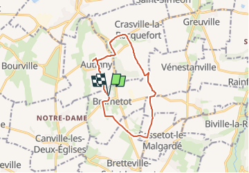

Length
10.9 km

Max alt
127 m

Uphill gradient
98 m
Km-Effort
12.2 km

Min alt
76 m

Downhill gradient
98 m
Boucle
Yes
Creation date :
2024-09-08 18:11:24.135
Updated on :
2024-09-08 18:12:58.611
2h46
Difficulty : Difficult

FREE GPS app for hiking
 SityTrail
IGN / Geographical institutes
SityTrail Plus
The world is yours!
About
Trail Walking of 10.9 km to be discovered at Normandy, Seine-Maritime, Brametot. This trail is proposed by juanluco76.
Positioning
Country:
France
Region :
Normandy
Department/Province :
Seine-Maritime
Municipality :
Brametot
Location:
Unknown
Start:(Dec)
Start:(UTM)
346372 ; 5516949 (31U) N.
Comments