


Regagnas

ja.13061965
User
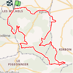

Length
29 km

Max alt
639 m

Uphill gradient
709 m
Km-Effort
38 km

Min alt
268 m

Downhill gradient
713 m
Boucle
Yes
Creation date :
2019-06-20 09:32:49.949
Updated on :
2019-06-20 09:32:50.166
4h18
Difficulty : Medium

FREE GPS app for hiking
 SityTrail
IGN / Geographical institutes
SityTrail Plus
The world is yours!
About
Trail Mountain bike of 29 km to be discovered at Provence-Alpes-Côte d'Azur, Bouches-du-Rhône, Peynier. This trail is proposed by ja.13061965.
Description
Superbe
Positioning
Country:
France
Region :
Provence-Alpes-Côte d'Azur
Department/Province :
Bouches-du-Rhône
Municipality :
Peynier
Location:
Unknown
Start:(Dec)
Start:(UTM)
710747 ; 4813938 (31T) N.
Comments