Trail  Saint-Martin-de-l'If - 2024-09-09_14h29m54_Cirkwi-Circuit_n°3__Le_Val_au_Cesne - Photo

2024-09-09_14h29m54_Cirkwi-Circuit_n°3__Le_Val_au_Cesne

© OpenStreetMap contributors
Length
Length
8.9 km
Max alt
Max alt
134 m
Uphill gradient
Uphill gradient
166 m
Km-Effort
Km-Effort  
11.1 km
Min alt
Min alt
51 m
Downhill gradient
Downhill gradient
166 m
Boucle
Boucle
Yes
Creation date :
2024-09-09 12:29:55.343
Updated on :
2024-09-09 12:29:57.546

(1 Reviews)


Scan this QR Code to open this trail in the SityTrail application

FREE GPS app for hiking

Logo SityTrail SityTrail

IGN / Geographical institutes

Download SityTrail from the App Store Download SityTrail from Google Play

Logo SityTrail SityTrail Plus

The world is yours!

Download SityTrail from the App Store Download SityTrail from Google Play Download SityTrail on Huawei AppGallery

About

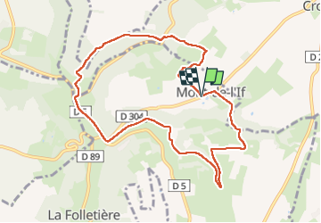
Trail of 8.9 km to be discovered at Normandy, Seine-Maritime, Saint-Martin-de-l'If. This trail is proposed by MichelRando7656.

Description

Découvrez l'étonnante mairie de Mont de l'If, construite dans un ancien manège et l'église ouverte toute l'année, pour commencer ce circuit. A mi-chemin, plongez au cœur du Val au Cesne,site naturel classé. Attention, les dénivelés seront importants pour atteindre ce paysage d'exception!

Elevation profile

Positioning

Country:
France
Region :
Normandy
Department/Province :
Seine-Maritime
Municipality :
Saint-Martin-de-l'If
Location:
Mont-de-l'If
Start:(UTM)
342729 ; 5495197 (31U) N.

Comments

Please log in to post a review or rate the element


Close
My subscriptions