


LL34-Tournemire-Roquefort

alainandrejoly
User
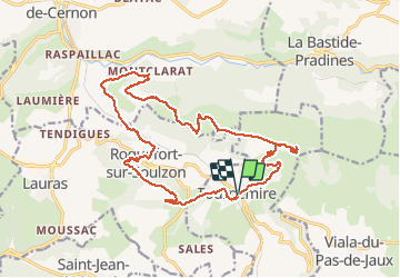

Length
21 km

Max alt
821 m

Uphill gradient
846 m
Km-Effort
32 km

Min alt
437 m

Downhill gradient
847 m
Boucle
Yes
Creation date :
2015-11-23 00:00:00.0
Updated on :
2015-11-23 00:00:00.0
5h39
Difficulty : Medium

FREE GPS app for hiking
 SityTrail
IGN / Geographical institutes
SityTrail Plus
The world is yours!
About
Trail Walking of 21 km to be discovered at Occitania, Aveyron, Tournemire. This trail is proposed by alainandrejoly.
Description
09/05/2015
Positioning
Country:
France
Region :
Occitania
Department/Province :
Aveyron
Municipality :
Tournemire
Location:
Unknown
Start:(Dec)
Start:(UTM)
501527 ; 4868433 (31T) N.
Comments