


col d'Aspain

any1950
User
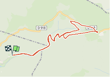

Length
6.6 km

Max alt
1494 m

Uphill gradient
353 m
Km-Effort
11.3 km

Min alt
1162 m

Downhill gradient
352 m
Boucle
Yes
Creation date :
2024-08-12 07:03:59.277
Updated on :
2024-09-12 12:17:22.395
2h29
Difficulty : Easy

FREE GPS app for hiking
 SityTrail
IGN / Geographical institutes
SityTrail Plus
The world is yours!
About
Trail Walking of 6.6 km to be discovered at Occitania, Hautespyrenees, Campan. This trail is proposed by any1950.
Description
belle rando à l'ombre
Photos

Positioning
Country:
France
Region :
Occitania
Department/Province :
Hautespyrenees
Municipality :
Campan
Location:
Unknown
Start:(Dec)
Start:(UTM)
279988 ; 4757398 (31T) N.
Comments