


Blanzey

any1950
User
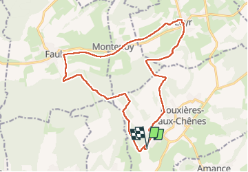

Length
18.9 km

Max alt
413 m

Uphill gradient
395 m
Km-Effort
24 km

Min alt
233 m

Downhill gradient
395 m
Boucle
Yes
Creation date :
2024-09-12 06:34:30.835
Updated on :
2024-09-12 12:17:23.828
4h41
Difficulty : Very easy

FREE GPS app for hiking
 SityTrail
IGN / Geographical institutes
SityTrail Plus
The world is yours!
About
Trail Walking of 18.9 km to be discovered at Grand Est, Meurthe-et-Moselle, Bouxières-aux-Chênes. This trail is proposed by any1950.
Positioning
Country:
France
Region :
Grand Est
Department/Province :
Meurthe-et-Moselle
Municipality :
Bouxières-aux-Chênes
Location:
Unknown
Start:(Dec)
Start:(UTM)
297594 ; 5404514 (32U) N.
Comments